Judul : Extreme Weather Still Lingers Over Indonesia, BMKG: Weak Monsoon and Atmospheric Waves Are the Triggers
link : Extreme Weather Still Lingers Over Indonesia, BMKG: Weak Monsoon and Atmospheric Waves Are the Triggers
Extreme Weather Still Lingers Over Indonesia, BMKG: Weak Monsoon and Atmospheric Waves Are the Triggers
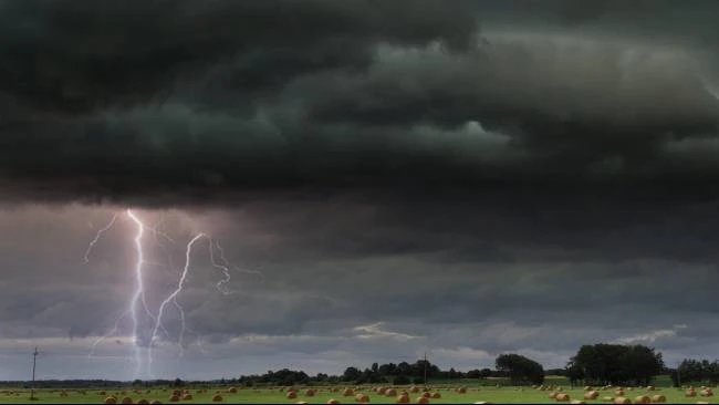
JAKARTA, Best for you — Although some parts of Indonesia should have entered the dry season, heavy to very heavy rain is still falling in several areas. The Indonesian Agency for Meteorology, Climatology, and Geophysics (BMKG) stated that active atmospheric dynamics and the weak Australian Monsoon are the main causes of this unstable weather condition.
Based on BMKG analysis until the end of June 2025, only 30 percent of the rainy seasons zones in Indonesia have entered the dry season period. This number is only half of the normal figure according to historical climatology.
It was mentioned that, at the end of June 2025, rainfall above normal levels was recorded in approximately 53 percent of Indonesia's territory.
Those regions cover most of Java, Bali, West Nusa Tenggara, East Nusa Tenggara, Kalimantan, Sulawesi, Maluku, and Papua.
Extreme weather phenomena reoccurred on July 2, 2025. BMKG recorded extreme daily rainfall at Deli Serdang Geophysical Station, North Sumatra, reaching 142 millimeters, as well as 103 millimeters at Rendani Meteorological Station, West Papua.
This condition occurs even though the Madden-Julian Oscillation (MJO) is in phase 2, or the Indian Ocean region, which usually does not support the formation of rain clouds.
According to BMKG, the still-moist atmospheric conditions in southern Indonesia are a result of the weak Australian monsoon.
In addition, some tropical atmospheric waves such as equatorial Rossby waves, Kelvin waves, and low-frequency waves are detected as active and contribute to the formation of convective clouds.
BMKG stated that this atmospheric disturbance is still detected spatially in the eastern part of Indonesia, such as South Sulawesi, Maluku, and Papua. This also triggers heavy local rainfall.
High air humidity and warm sea surface temperatures also strengthen the convection process and rain cloud formation in various regions. This causes extreme weather to still have the potential to occur in the coming days.
Forecast Period July 7-10, 2025
BMKG predicts that during the period of July 7-10, 2025, most areas of Indonesia are still likely to experience rain with light to moderate intensity.
While heavy rain accompanied by lightning and strong winds is predicted to occur in the following areas:
- Alert Category: Maluku
- Category Alert: Mountainous Papua
- Strong Wind: Riau Islands, West Java, Central Java, Yogyakarta Special Region, East Java, Bali, West Nusa Tenggara, East Nusa Tenggara, North Sulawesi, Central Sulawesi, South Sulawesi, Maluku, Papua, and South Papua.
BMKG is also monitoring the activity of a low-pressure system around Indonesia. The tropical cyclone seed 98W located near Luzon Island has not yet directly affected the territory, but it contributes to increasing wind speed in the South China Sea and northern Philippines areas.
In addition, the cyclonic circulation in the Indian Ocean and the northern Pacific Ocean near Papua New Guinea forms a convergence zone crossing the Java Sea, Flores Sea, up to the central and southeastern regions of Sulawesi. As a result, the chances of heavy rain in these areas also increase.
BMKG also recorded an increase in wind speed above 25 knots in the Andaman Sea area, southern West Java, and southern Papua New Guinea. This could potentially cause high waves in the open sea.
BMKG Advisory
Faced with the potential of extreme weather in the coming days, BMKG urges the community to remain alert, especially those living in areas prone to hydro-meteorological disasters.
Here are some recommended precautionary steps:
- Use a sunscreen or sunblock when engaging in outdoor activities.
- Sufficient fluid intake to avoid dehydration.
- Avoid open areas and fragile structures during strong winds or thunderstorms.
- Stay alert to the potential of flooding, flash floods, and landslides.
- Monitor weather developments through BMKG official channels such as the website bmkg.go.id , InfoBMKG application, and social media @infoBMKG.
BMKG emphasizes that the atmospheric conditions are still very dynamic and will continue to be updated according to the latest developments.
Demikianlah Artikel Extreme Weather Still Lingers Over Indonesia, BMKG: Weak Monsoon and Atmospheric Waves Are the Triggers
Anda sekarang membaca artikel Extreme Weather Still Lingers Over Indonesia, BMKG: Weak Monsoon and Atmospheric Waves Are the Triggers dengan alamat link https://www.punyakamu.com/2025/07/extreme-weather-still-lingers-over.html
0 Response to "Extreme Weather Still Lingers Over Indonesia, BMKG: Weak Monsoon and Atmospheric Waves Are the Triggers"
Post a Comment